Started at five-something, and walked down to where the bus departed from - a 10-15 minute walk from Chirrup. Although I was in good time, they seemed quite excited by my arrival. In fact we seemed to wait another 20 minutes or so for the final passenger to board. I was slightly worried they were missing one passenger that could be my pack, as I had paid for an extra seat so my pack didn't disappear into the boot of the bus, out of sight etc. 20 soles per ticket, and worth it to avoid turning up to trek with no bag. The bus was called the Yungay Express, which slightly confused me, as I thought Yungay was this side of the range. Worked out that we did go to Yungay, then up into the mountains. Think the bus was heading to Yanama, on the other side of the Cordillera. I had difficulty physically shifting my bag on board on as it almost didn't fit through the doorway. A woman by the stop was selling a revolting-looking liquid in plastic bottles - dark gungy brown stuff, which several passenger elected to purchase, though I notice the woman sitting next to me didn't get very far into the bottle!.
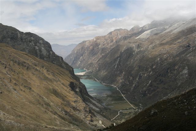
So off we go - the journey time was about 4 hours. After approximately two, we headed up into the hills, stopping at a checkpoint along the way where I had to pay for a "park pass" at $18. No one else had their names in the log book, I wondered how busy the trail would be. At this stop, everyone on board bought a boiled sweetcorn, with especially bulbous "seeds" (what are the individual bits called - niblets?!) but I didn't want to get food poisoning now of all times, so didn't partake. We drove on past two beautiful lakes, the Lianganuco Lakes, with a gorgeous turquoise colour, apparently caused by mineral particles from glaciers, then up an almost sheer face via a long series of switchbacks.
On a particularly sharp turn there was a collection of crosses with initials on, obviously where a vehicle had plunged off the edge. Gulp. We turn the corner, only to meet a large truck. How on earth can we pass each other? Simple! We reverse back to the corner with the crosses. One's faith in the driver was somewhat weak at this point, but he pulled through. The high pass we crossed at 4767m, [GPS: 09.05024S, 77.58986W] which I believe is the highest I've ever been on land. then dropped rapidly, coming to my trailhead, at Vaqueria. I jumped off, the only one to leave the bus here, by a couple of tiny roadside shacks, and did question briefly what on earth I was doing here!
I set off down the road, only to question what the map was telling me - I could see a perfectly good trail heading in the right direction, the map suggested I should carry on down the road. This was to be the first of many innacuracies which cost me dear! So doubled back, and headed round on the main trail, soon splitting off at Huaripampa to take a side trek up the Ranincurary valley up to a pair of lakes called Tintacocha which sounded nice, although one of the owners of Chirrup had told me not to do it, as it would be too tough, especially for the first day. It was an 800m ascent (once branching off the main trail), which didn't sound too bad! What soon became apparent was that this was a rarely used side-trek. In the time I spent off the main path I met not one single person! Furthermore my map was implying river crossings where the were none, and vice-versa, so I got lost and ended up hacking my way through dense trees and undergrowth, picking up numerous scratches along the way. Luckily the path was slightly more obvious on way down.
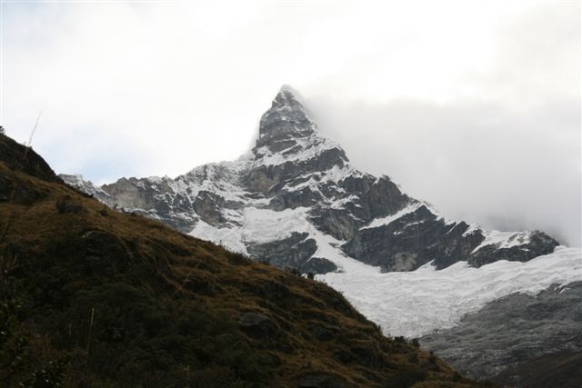
So up the valley until approaching the ridge which cuts across the valley holding the lakes above. How was one supposed to ascend this? There was no obvious path. My map implied that one should head up the left hand side, turning sharply left as one surmounted the ridge to the first lake. This proved almost impossible. I noted as I slowly and painfully made my way up that the far, or right hand side of the valley looked much easier, and so I would try descending this way. spectacular views. On reaching the top, a small but pretty lake came into view, nowhere near worth the effort of the climb though, except that rearing up behind was one of the spectacular Nevada Chacraraju peaks, at either 6112 or 6001m (I'm not sure which one I was looking at, probably the "lower" one).
Suddenly darkness descended. I don't think I've ever been in a place where night came over so fast - in the space of 10 minutes it went from daylight to dusk. I began to panic, as I had nowhere to camp. My LP trekking book had mentioned "great camping" up here! Where?! There was thick long grass everywhere! I found a small spot, too small for my tent, which I'd never put up before! Tent hastily erected, not perfectly (which I would regret later), and it started to rain. In to tent and wait for dawn. No dinner as it was pouring. I made do with some Jalapeno pringles. I have to say that there is no way this is a 2-man tent. There's not enough room inside for my pack and me - the pack has to sit in the porchway area. Two men?! Plus unless I'm not erecting it correctly, when I stretch out, unless I'm perfectly aligned with the door, I end up pushing the inner tent to the outer layer, thereby letting water in. Two man?! [GPS 08.98027S, 77.58021W] Then the lightning started. I wondered whether my hastily picked spot was exposed. I think we were at about 4200m. In the distance the waterfall feeding the lakes roared. I prayed for morning...


No comments:
Post a Comment